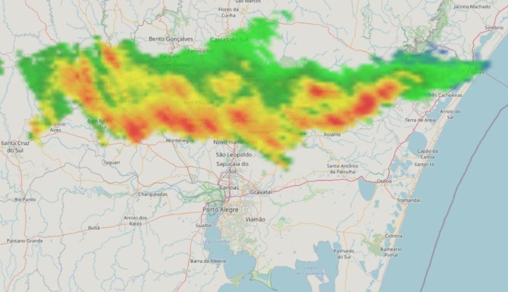
Radar images showed strong instability between the Valleys and Serra Gaúcha at the end of Tuesday with heavy rain and thunderstorms | DECEA
The approach of colder air along the coast induced strong instability at the end of Tuesday and in the early hours of this Wednesday in parts of the Northeast of Rio Grande do Sul, such as in the valleys, in the Serra and in Greater Porto Alegre. The rain was locally strong to intense with high volumes in some locations, to the point of causing flooding in sectors of the Taquari Valley.
The instability at the end of the day and in the early hours of today occurred after a hot Tuesday afternoon with unseasonable heat in which maximum temperatures reached 29.4ºC at the Campo Bom meteorological station and 29ºC in the city of Porto Happy.
The accumulated rain between yesterday and today at six in the morning totaled 95 mm in Lagoa Bonita do Sul, 91 mm in Três Coroas, 58 mm in Venâncio Aires, 49 mm in São Francisco de Paula, 41 mm in Estrela, 38 mm in Cruzeiro do Sul and Lajeado, 29 mm in São Sebastião do Caí, 26 mm in Campo Bom, 22 mm in Alto Feliz and Nova Petrópolis, 21 mm in Canoas and Bento Gonçalves, and 20 mm in Eldorado do Sul.
In Porto Alegre and the metropolitan region, the rain started lightly in most places at the end of Tuesday. In Vale do Sinos, close to Serra, the rain was more intense. Between 2am and 3am this Wednesday, precipitation intensified in the Porto Alegre region with a brief period of moderate to heavy rain.
The strong areas of instability at the end of Tuesday and in the early hours of this Wednesday have already disappeared, but satellite images at dawn this Wednesday still showed an abundant presence of clouds in the Center and in the Northern Half of Rio Grande do Sul. The weather was more open in the South and on the border with Uruguay.
During this Wednesday, however, a large part of the state should have steady weather with sun and clouds, although with cloudy to overcast periods mainly in cities in the Northern Half of Rio Grande do Sul. Therefore, sunny openings occur today in Porto Alegre, but a substantial part of the day will have many clouds. There is still a chance of irregular, mostly weak precipitation in sectors of the Northern Half.
The arrival of milder air brings lower temperatures mainly in the Center, South and East of the state, where it is cooler with the minimum temperatures occurring at night, at the end of the day, with temperatures between 13ºC and 15ºC in different parts of these regions. Several cities in the South and Campanha should have maximum temperatures of just 21ºC to 23ºC.
Colder air entering part of the state will be responsible for a cooler morning on Thursday. The Campaign and the border with Uruguay should have minimum temperatures of 10ºC to 12ºC, but in some points the temperature may drop below 10ºC. Porto Alegre can be around 14ºC, but in the south of the city it can be less. In the mountains, the minimum temperatures should be around 10ºC to 12ºC.
MetSul Meteorologia is on WhatsApp channels. Subscribe here to access the channel in the messaging app and receive forecasts, alerts and information about the most important events in the weather and climate in Brazil and around the world, with exclusive data and information from our team of meteorologists.
Tags: Heavy rain hits cities Rio Grande Sul unseasonably hot weather Tuesday
--


