
A cold front advances through Rio Grande do Sul this Saturday and will bring heavy rain to several cities and also the risk of isolated thunderstorms. The front will be preceded by heat in the Northern Half and will bring a sharp drop in temperature between today and tomorrow. | FABIAN RIBEIRO
MetSul Meteorologia warns that a cold front will advance through Rio Grande do Sul this weekend with heavy rain in several cities and the risk of some isolated storms. The frontal system, in addition, will be followed by a sharp drop in temperature with the entry of colder air after a hot Saturday in part of the state of Rio Grande do Sul.
A warm front advanced from North to South yesterday in Rio Grande do Sul with rain in the West, Center, South and East of the state. The front was formed from the advance of very hot and dry air from the Northeast of Argentina, which opened the weather yesterday with sun and heat of up to 34ºC, as expected, in the West, Northwest and North of Rio Grande do Sul.
The system also reached neighboring Uruguay, where hail fell on Friday in several departments in the Uruguayan interior, including reports of medium to large stones in some locations, such as Canelones, Cerro Largo and Lavalleja.
Today, the same front takes the opposite path. Since it will be driven this time by cold air, it will now be a cold front that will move from South to North with a new change in the weather in the state of Rio Grande do Sul that will bring rain to most regions and the risk of isolated thunderstorms this Saturday.
The cold front brings rain between dawn and morning to several parts of the West, Campanha and South of the state, especially close to the border with Uruguay. The risk is high on the border with Uruguay, Campanha and in the South of Rio Grande do Sul of heavy to torrential rain with excessive volumes in a short period with flooding and flash floods. There is a chance of localized storms with lightning, wind and hail.
The front will then move to the Center and North of the state from the afternoon to the evening this Saturday, where the sun appears first with heat and a North wind. The wind, due to the relief, can raise the marks on the thermometers to values of 33ºC to 35ºC in the valleys.
The cold front, upon encountering warm air as it moves through Gaucho territory in the second half of the day, will have heavy clouds capable of causing locally heavy rain and isolated thunderstorms in which the possibility of hail and localized gales cannot be ruled out.
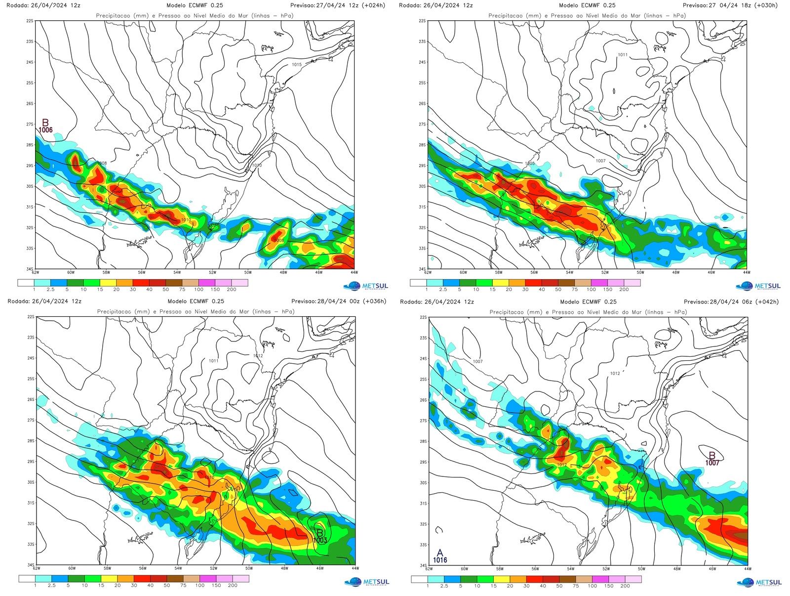
The maps below show the projection of rain and atmospheric pressure from the European Meteorological Center (ECMWF) model every six hours for the morning, afternoon and night of this Saturday, in addition to the early hours of Sunday. It is observed how the maximum activity of the front will occur from the Center to the South of Rio Grande do Sul this Saturday and how it will rain a lot in part of the Rio Grande do Sul territory.
METSUL
In Porto Alegre, Saturday will have sun and clouds with heat and stuffiness. The temperature can be close to or reach 30ºC. The cloudiness will then increase and the weather will become unstable with rain. It rains more from the middle or end of the afternoon and at night, continuing at the beginning of Sunday.
A strong wind will not move away when the cold front arrives in Greater Porto Alegre later today and there is a risk of heavy rain, especially between Saturday night and the beginning of Sunday in the capital and the metropolitan area, not ruling out high volumes in the metropolitan region.
This front will have a greater impact on Rio Grande do Sul and a lesser impact on Santa Catarina. This is because the frontal system will not be able to progress much to the North in the South of Brazil due to the atmospheric blockage associated with a large mass of dry and hot air over the Center of the country, where the weather will remain firm and with temperatures well above normal for this region. time of the year.
Sharp drop in temperature with the cold front
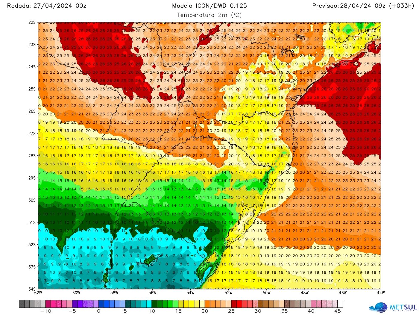
Colder air advances behind this cold front and will enter Rio Grande do Sul this Saturday with a sharp drop in temperature after the arrival of the cold front that divides the mass of hot and cold air with instability. Therefore, Saturday will end with temperatures of up to 13ºC to 14ºC in cities on the border with Uruguay, Campanha and the South of Rio Grande do Sul, before a cold dawn in these regions on Sunday.
METSUL
The map above shows the temperature projection from the German weather model Icon for dawn this Sunday. As you can see on the map, Sunday will start with milder temperatures in much of the state and even with cold temperatures in parts of the Center, West and South, with temperatures around or just below 10ºC in Campanha and Serra do Sudeste . Further to the North and Northwest, although it will be refreshing, the effect of the cold air will be small.
Throughout next week, Rio Grande do Sul will be between colder air to the south and a powerful mass of hot air over Brazil. Depending on the day, sometimes warmer air advances from the North to the state, and sometimes colder air will move from the South to the Rio Grande do Sul territory. Since it will be in the transition zone between the two air masses, hot and cold, instability will be frequent with the expectation of a lot of rain.
How to consult the maps
All maps in this bulletin can be consulted by our subscriber (subscribe here) in our maps section at any time. The platform offers maps of rain, frost, temperature, risk of hail, wind, humidity, atmospheric pressure, snow, soil moisture and risk of fire and lightning, among other variables, with updates two to four times a day, according to each simulation. In the maps section, you can also consult our very high resolution WRF model of MetSul.
MetSul Meteorologia is on WhatsApp channels. Subscribe here to access the channel in the messaging app and receive forecasts, alerts and information about the most important events in the weather and climate in Brazil and around the world, with exclusive data and information from our team of meteorologists.


