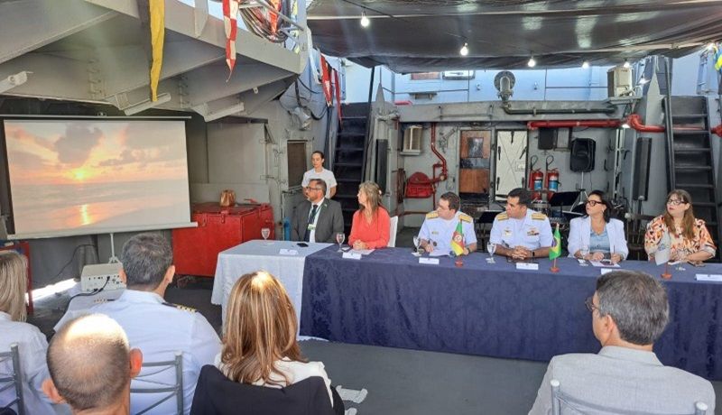
The meeting took place on board a Brazilian Navy patrol ship, moored at Cais Mauá, in Porto Alegre
On board a Brazilian Navy patrol ship, moored at Cais Mauá, in Porto Alegre, technical studies for the implementation of Marine Spatial Planning in the Region began this Thursday morning (25/4). Southern Navy of Brazil (PEM-Sul). Although it is a national instrument, Rio Grande do Sul was chosen to start the project considering its territorial planning in coastal areas and the available database.
“For Rio Grande do Sul, it is a recognition that we are giving this start. The State government has already understood the need for unity between the environment and economic development. We stand out, not only for having the largest port in the south of the country, but also for our wind potential onshore It is offshore, in addition to green hydrogen. We want the PEM because we value our natural riches and we want to organize these potentialities and weaknesses, making the best use of this territory that is so important for Brazil”, highlighted the Secretary of the Environment and Infrastructure, Marjorie Kauffmann, who represented Governor Eduardo Leite in the event.
The federal government’s Marine Spatial Planning (PEM) program has resources from the National Development Bank (BNDES) and is coordinated by the Interministerial Commission for Sea Resources (CIRM). In the South region, the execution will be carried out by the Rio Grande do Sul company Codex, in partnership with the Federal University of Rio Grande do Sul (UFRGS) and the Federal University of Rio Grande (Furg).
The technical study, which began in January 2024, will last up to 36 months and will involve the elaboration of a diagnosis of current and potential uses, the construction of a support tool (Geoportal) and the publication of the PEM, considering marine and its reflections in coastal areas.
The coasts of the states of Paraná and Santa Catarina will also be covered. According to the federal government, the South region was the first chosen because it is part of the border with Uruguay and belongs to 13% of the Blue Amazon, integrating five of the ten most relevant ports in the country.
“This initiative is strategic not only because it mandates the economic use of the sea, but also because it helps preserve the environment. It will be a vital tool for national sovereignty and for future generations to benefit from the riches of our sea”, stated Vice Admiral Augusto Fonseca Júnior.
The Blue Amazon encompasses the area of Brazil’s Exclusive Economic Zone (EEZ), up to approximately 650 kilometers from the coast. According to the Ministry of Environment and Climate Change (MMA), the project will identify and map the different uses of the ocean, such as fishing, maritime transport, tourism, energy production, research and biodiversity conservation.
In addition to mapping, the PEM intends to avoid exploration in risky regions, allocating suitable areas for each activity, promoting the preservation of marine species and guaranteeing legal security for economic activities. The plan proposes as a goal development aimed at the shared, sustainable, inclusive and socially fair use of the marine environment.
The general coordinator of Coastal and Ocean Management at MMA, Marinez Scherer, highlighted that planning is the set of public policies crucial for mitigating climate change, avoiding, among other things, the rise in temperature and sea level. The initiative fulfills the commitment made by the country during the United Nations Ocean Conference, in 2017, to implement the PEM in Brazil by the year 2030.
Among the authorities, the Secretary of Economic Development, Ernani Polo, and the president of the State Foundation for Environmental Protection, Renato Chagas, participated in the event. Representatives from the Public Ministry and other state departments were also present.
The program for the event held in Porto Alegre lasts throughout the afternoon, with conversations between representatives of the State secretariats about the national PEM and PEM-Sul and a workshop focused on participatory mapping.
Ascom Sema RS
Photo: Vanessa Trindade/Ascom Sema RS
Click here and join our News Channel on WhatsApp
Share on your Social Networks
Tags: pilot studies development Marine Spatial Planning Southern Region Brazil
--


